The saturation of multispectral beams and increasing presence of electromagnetic radiations in the modern battlefield can be handy on one hand but it can create massive interference which may lead to absolute failure of command and control systems.
This has opened the way for increasing convergence in recent years between ISR (Intelligence, Surveillance and Reconnaissance) and AEW (Airborne Early Warning)/Command and Control Battle Management (C2BM) mission sets.
The ultimate goal for airborne ISR and AEW/C2BM is to enable decision superiority and this will continue to be enabled by the confluence of hardware assets and the operators and analysts.
However, budgets will underpin the makeup of future capabilities and dictate the economics of introducing new platforms versus upgrading capabilities as existing platforms approach critical junctures in their operational lifecycle.
In the case of radar systems, demand will come from existing platforms being retrofitted and upgraded, as well as opportunities from new manned and unmanned platforms as the nature of warfare is fast changing.
Operational effectiveness
The changing face of warfare (conventional versus asymmetric) moving towards hybrid scenarios will be underpinned by joint operations and will require interoperability to allow effective operation in congested and contested environments.
Ultimately, the emphasis needs to be on information sharing, not collection of data for collections sake. Despite the move towards advanced sensors, automated software capabilities and unmanned platforms, the ‘human-in-the-loop’ remains the most important asset.
The importance of continued and effective training will be essential to ensure that platforms and assets achieve the desired effects.
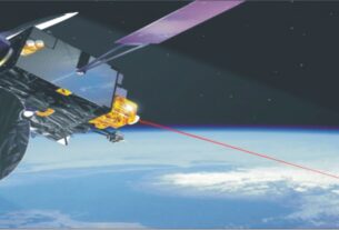
Many nations have powerful space-based image intelligence (IMINT), signals intelligence (SIGINT), and measurement and signatures intelligence (MASINT) collection systems and are in the process of developing even greater capabilities.
It is essential that naval forces have access to data from these capabilities and that they be able to task the capabilities.
Normally, IMINT systems provide photographic coverage over denied territory that, through the science of stereophotogrammetry, enables precise geodetic positioning of targets on the ground.
For decades these capabilities have provided the means for precision strike against fixed targets; as the speed of tasking, collection, and processing has increased, the same capabilities have begun to put relocatable targets at risk.
The US has taken a lead in this segment. New satellite constellations are in progress under the Future Imagery Architecture program of the US National Reconnaissance Office (NRO).
SIGINT systems have global coverage and provide geodetic positioning of platforms emitting at radio frequencies.
Their product is quickly and widely broadcast to tactical forces afloat and in the field, where it is used for strike targeting and defense avoidance and suppression, among other purposes.
The US Defense Support Program (DSP) satellites for decades served as sentinels for the early warning of the launch of strategic intercontinental ballistic missiles.
In recent years the infrared-based MASINT data from these satellites have been exploited to cue systems defending against shorter-range tactical ballistic missiles.
In addition, the DSP ability to estimate launch points enables counterattack against elusive Transportable Erector Launchers (TELs). New, more capable systems denoted Space-Based Infrared Systems (SBIRS) High and Low are under development.
Defense Meteorological Support Program (DMSP) satellites and related space, atmospheric, and surface observations are used by the Fleet Numerical Meteorological and Ocean Center (FNMOC) to make now-casts and forecasts of a wide variety of oceanographic and atmospheric variables.
Such surface wind and wave forecasts are of the utmost importance in naval operations as well as in planning ISR observations.
FNMOC forecasts are especially valuable over ocean areas where other meteorological forecasting services do not provide the information necessary for effective naval air and surface operations.
Extended capabilities
Indeed, future ISR capabilities should be developed with the overarching intelligence needs in mind, rather than the platforms that carry the sensors or the medium that the sensors operate in.
In future, these ISR capabilities in theatre should be co-ordinated by the Joint Commander to ensure he can substitute one capability for another to achieve the same effect, whilst fully supporting his subordinate commanders.
This will improve the ability to integrate data from all sensors, including civilian ones and ensure timely intelligence is available to those who require it.
Network enabled architecture and the ability to conduct spectrum management will be essential. 10. Operations against irregular adversaries are often less a question of force size but more about the Intelligence, surveillance and reconnaissance capabilities, which are strategically important in peacetime, are a vital national asset in crises when time is a critical factor in decision-making and demands for information escalate drastically.
This is why estimates of what a country will need in a crisis drive ISR force planning, which include such factors as ISR platform design; operating parameters; sensor coverage and redundancy; and the collection, analysis and dissemination of information to political decision makers and military commanders.
In recent years, Japan’s security environment has grown increasingly less secure, making the collection and dissemination of intelligence, surveillance and reconnaissance information more important than ever to Japan’s defence.
To see is to understand, and to understand is to make timely and prudent decisions. In Japan’s increasingly uncertain security environment, a robust, carefully developed and effectively integrated ISR capability is essential.
Japan’s national ISR capabilities can be envisioned in the context of a number of operational scenarios that define Japan’s international security environment: the Sea of Japan, the East China Sea, the South China Sea, the Ryukyu Islands and the Horn of Africa.
Through broader information sharing arrangements, Japan can rely on the United States, and perhaps other allies and regional actors, for some of this capability.
Still, Japan is taking steps to enhance its own capabilities. There are five components of a modern, integrated ISR capability that could greatly improve Japan’s defense capabilities.
To start, very high-altitude unmanned aircraft are available to Japan for the first time thanks to technological breakthroughs, providing a host of new opportunities and choices for ISR capabilities.
With these aircraft, Japan could extend its ISR horizon dramatically. The ability to see and hear much farther and earlier would substantially enhance Japan’s defense and provide earlier warning of regional security developments.
Second, effective ISR is operationally demanding and can be especially taxing on pilots who fly reconnaissance missions.
New unmanned systems, therefore, allow significant economies of force for crewed Self-Defense Force operations. Third, enhanced Japanese ISR would fill existing national informational and operational gaps.
Fourth, a national system of systems approach would increase the effectiveness of Japan’s ISR mission. ISR command and control and analysis are key system functions across Japan’s Self-Defense Forces and throughout its national self-defense infrastructure.
Japan is considering as how to connecting strategically relevant ISR capabilities with those of its principal ally, the United States, and other international partners. A Japanese national ISR planning dialogue that parallels alliance planning discussions would be part of a larger aerospace capabilities planning process.
In fact, intelligence, surveillance and reconnaissance are critical to a nation’s strategic defence. Many nations are actively employing ISR throughout the global commons of sea, air, space and cyberspace in order to collect, process and disseminate data in support of current and future national security needs.
Some ISR activities are related to a specific domain or military service. Naval platforms, for instance, focus on naval and maritime activity.
Other ISR operations occur at higher organizational levels, such as the National Reconnaissance Office in the United States.
Some intelligence operations, often at the national level, get direct support from ISR efforts, providing them with early warning and tactical military information.
ISR can enhance the capabilities of self-defense systems both individually and collectively. Both militaries and civilian governmental entities conduct national ISR operations.
Intelligence, surveillance and reconnaissance comprise a crosscutting national security function. Military forces are often responsible for collecting information concerning another state’s military plans, force structure and levels, force disposition and current operations.
ISR also makes a vital contribution to strategic and operational early warning. ISR involves remote information gathering that depends on either visual observation or enhanced visual observation via electro-optical means (imagery intelligence) or enhanced listening via specialized receivers (signals intelligence).
Role of sensors
ISR sensors can see and hear across the frequency spectrum. Individual sensors are designed to exploit specific frequency bands that humans associate with their own senses. While some platforms and even some sensors are multifaceted, platform missions and technical and operational disciplines have formed around these frequency bands.
ISR can be viewed as a system of systems-an explicitly designed, operated and maintained combination of individual reconnaissance systems-that collect information across the electromagnetic spectrum.
As such, ISR is foremost a family of collection capabilities that, taken together, can provide a more complete picture of another nation’s military operations.
This means that some ISR platforms may have more than one sensor and that other ISR technologies are designed to collect information unavailable by other means. Satellites are representative of this latter ISR capability.
ISR sensors are becoming increasingly complex, providing greater resolution than ever before, and in smaller and lighter packages that require less power to operate.
This means that airborne and orbiting technology with mounted ISR sensors can provide better performance at lower cost, thereby putting these tools within the reach of nations with even modest defence budgets. Modern ISR technologies are also becoming increasingly powerful. Both purpose-built UAVs with ISR capabilities and militarized modern commercial aircraft continue to increase in range, airspeed, altitude and endurance.
An example of this trend is the P-8 Poseidon, a military aircraft Boeing is currently developing for the United States Navy.
The P-8, a variant of Boeing’s commercial 737 airplane, will eventually replace the US Navy’s capable but aged P-3 Orion (itself a militarized version of the Lockheed Electra commercial aircraft).
Advances in remote operation technologies, along with enhanced sensors, have revolutionized the use of UAVs.
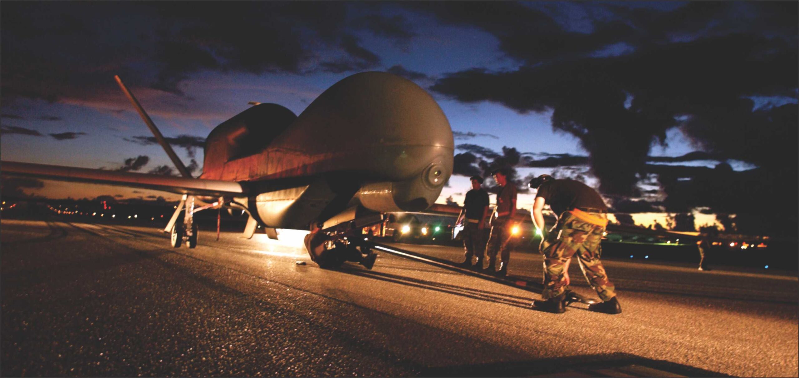
These intelligence, surveillance and reconnaissance UAVs range from very small, hand-launched versions to much larger, transcontinental-range versions such as RQ-4 Global Hawk-an unmanned, high-altitude, long-endurance aircraft-which far exceeds the performance of the U-2 Dragon Lady in terms of mission duration for lower cost-a manned, high-altitude surveillance aircraft used by the United States Air Force.
Traditional Aerospace ISR Approaches National leaders and military planners are competing against their counterparts in other countries to collect strategic, operational and tactical national security information.
Given that ISR is a tremendous national security enabler, the country with the best collection capability has a significant advantage. (Denial and deception capabilities are also an important part of the ISR competition.
Conversely, nations without effective ISR are at a serious national security disadvantage. Traditional approaches to aerospace ISR have taken a layered approach.
In layered ISR operations, commanders use multiple assets in combination to obtain sensor coverage over a larger area and during a longer period than any one asset can achieve.
To achieve the intended goal, the commander must develop the optimal mix and positioning of strategic-level assets, such as satellites or high-altitude UAVs, and tactical level assets.
Technologies and assets that have longer endurance and wide-area sensors that can perform the initial search and detection capability of an area are generally the best candidates for layered ISR operations.
This allows more tactical platforms with lesser endurance to fully share information with wide-area search technologies.
Potential advantage
Aircraft and satellites have provided intelligence, surveillance and reconnaissance of potential adversarial forces for decades, from their early Cold War origins in which bombers and fighter aircraft were modified for reconnaissance up to the conceptual, doctrinal and technological breakthrough of the U-2 Dragon Lady.
These have included low-altitude and medium-altitude tactical reconnaissance aircraft, reconnaissance satellites and high-altitude strategic reconnaissance aircraft.
Historically, many nations have fielded tactical reconnaissance aircraft. A partial inventory of US Cold War-era tactical reconnaissance aircraft includes the RF-86F Sabre, the RF-4 Phantom and the photo pod-equipped F-15 Eagle and the P-2 Neptune and the P-3 Orion (a versatile maritime patrol aircraft with an ISR mission, and with specialized ISR variants such as the EP-3E ARIES).
Like tactical reconnaissance aircraft, specialized ISR aircraft operating in the mid-altitude strata have proliferated widely. American ISR aircraft have included the RB-47 Stratojet (eventually phased out and replaced by the much more capable U-2 and the SR-71).
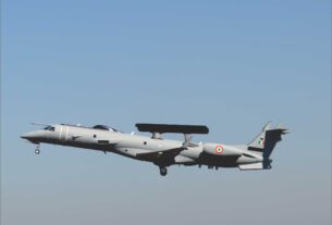
Similarly, the diverse USAF family of EC/RC-135 aircraft (typical of larger “big wing” aircraft optimized for ISR missions) and the now-retired EC-121 Warning Star, the E-3A Sentry Airborne Warning and Control System (AWACS) and the E-2C and E-2D Hawkeye (Air Force and Navy early warning and control aircraft).
There are only a few examples of manned high-altitude strategic reconnaissance aircraft, including the U-2 Dragon Lady and the SR-71 Blackbird.
These specialized aircraft are typically built for a specific purpose; operate at high levels of performance; and require specialized engineering, support and operations.
They are essentially equivalent in performance to orbiting satellites, although with a different flight profile. They are national strategic assets and extraordinarily expensive.
Until now, their highly sophisticated aeronautical and sensor technologies have kept them beyond the reach of most nations. As a result, few countries have been able to afford to design, build, or operate this class of aircraft.
Orbiting reconnaissance satellites cannot replicate every capability of the low-through high-altitude manned ISR platforms, but they conduct some missions well.
With the advent of extraordinarily sensitive reconnaissance cameras, other radar imaging and electronic sensors and tacit international agreement not to interfere with satellite reconnaissance, orbiting ISR satellites can survey vast swathes of territory in periodic sweeps.
Geostationary satellites can stare at a particular region with a variety of sensors for specialized missions.
Significantly, in addition to national reconnaissance satellite programs, there are now numerous international and commercial reconnaissance satellites that carry a variety of electro-optical and synthetic aperture radar sensors.
This emerging market reflects not only the advances in launch technology and satellite operations, but also the development and proliferation of sophisticated sensor technologies and packages.
The ISR Spectrum ISR has multiple functions, including information gathering based on imaging (imagery intelligence) or signals collection (signals intelligence).
The information provided by ISR is valuable to decision makers only after it has been converted into a useable form in a timely manner.
The rapid sharing of information among military leaders and civilian government officials is key to maintaining situational awareness and establishing a common operational picture.
Combined and collated ISR information is far more valuable than its individual components. In other words, the whole is greater than the sum of its parts.
Timely signals
Layered ISR can include the use of satellites, high-altitude UAVs and lower-altitude or tactical assets. Aircrafts and other assets with longer endurance and wide-area sensors are most useful in providing the initial search and detection capability of an area.
This enhanced capability allows wide-area search technologies to cue or send signals instantly to more tactical platforms with lesser endurance. ISR has experienced six main trends in recent years.
First, more space-based ISR information has become available to civil, military, commercial and private consumers.
Second, low-through high-altitude ISR platforms remain necessary because reconnaissance satellites cannot replicate every ISR capability.
Third, developments in sensor technology are making ISR cheaper, smaller and lighter.
Fourth, digitization of imagery is reducing the weight and expense of technology for various platforms and giving decision makers more options.
Fifth, the growing development and fielding of multiple types of UAVs is creating a greater distribution of tactical ISR capabilities.
Sixth, despite a variety of technical advancements in ISR, high-altitude systems remain unique, because they offer penetrating coverage at a standoff range from a neighboring country that no other system can provide.
Very high-altitude, long-endurance (HALE) ISR-equipped UAVs can now provide around-the-clock information.
Indeed, a balanced intelligence, surveillance and reconnaissance capability gives national decision makers greater opportunities in detecting activity in the global commons from farther away and more flexibility when making timely national security decisions.
A balanced ISR force also provides additional layers of capability. From a decision maker’s perspective, the overlap and redundancy provided by a capable ISR force are especially important factors in being able to take confident action.
A balanced ISR force also provides operating economies, substituting where appropriate unmanned platforms that reduce the burden on crewed platforms.
Well-integrated ISR assets and capabilities are also important to national leaders. Not every sensor or platform can detect all activity in its field of view, and of course no sensor can see everywhere.
These limitations put a special value on the system of systems design and command and control of ISR capabilities, and on the integration of information developed by the ISR force.
The implication is that, while ISR platforms and sensors must be connected in a network, the ISR system of systems extends well beyond the platforms, sensors and crews conducting these missions.
Command and control, analysis and distribution functions and organizations are additional essential mission elements that make up a modern ISR capability.
New developments
The United States is the only country that operates intelligence, surveillance and reconnaissance forces at every altitude.
Still, the ISR club of nations is becoming larger and increasingly competitive. Countries that were once holding their own in the ISR competition must work harder to keep up, while countries that are lagging are at risk of falling further behind.
Several developments are driving the expansion of ISR capabilities and the intensity of ISR competition. First, space is no longer is an exclusive enclave. Eleven nations are now orbiting ISR satellites, and that number is expected to increase to 21 in 2017.
The international availability of commercial reconnaissance satellites means that both state and non-state actors can benefit from space-based ISR without the expense of national space programs.
This commercial benefit is, of course, offset by the insecurity of commercial sources in times of crisis. Second, new sensor developments are making modern ISR cheaper, smaller and lighter.
This affects the ISR chain at every level: Very sophisticated ISR payloads have become much easier to fly. Third, digitization of photography reduces problems of weight and expense.
Despite their intense development in the mid-1950s, early U-2 camera magazines still contained two miles of very wide format film.
Cumbersome in-flight aircraft recovery systems were designed to snatch film canisters ejected from early photo reconnaissance satellites.
However in modern ISR, digitization of all-spectrum collection-not just imagery-drastically reduces the need for these recovery systems and avoids weight penalties.
Fourth, the globalization of aircraft manufacturing has led to the modification of more airframes of various sizes to carry ISR sensor packages.
These airframes are affordable for many more users; the commercial price is a steep discount from having to maintain a costly national aircraft manufacturing capability as a national security priority.
Fifth, the explosive development and fielding of UAVs have prompted a broad distribution of tactical ISR capabilities.
Just as with manned aircraft, sensor packages can be mounted on these vehicles and the absence of life-support systems makes additional room for sensors.
However, the higher echelons of ISR have experienced a less dramatic impact, as has the globalization of aircraft manufacturing more generally. High-altitude systems remain a unique commodity.
They are rare on orbit and even rarer in the upper reaches of the atmosphere. But new HALE UAV aircraft, such as the RQ-4 Global Hawk, are the bellwether of change.
These developments have implications for current and future members of the ISR club. Strategically relevant ISR capabilities at every altitude are now within reach of most of the Group of 20 industrial and emerging-market nations.
The imminent availability of higher ISR operating altitudes means that penetrating reconnaissance without atmospheric over flight will be increasingly common.
The HALE UAV ISR platforms operating on 24-hour flight schedules will be able to provide around-the-clock information.