
Sharpening accuracy
Navigation gives precision to warfare. Its tools have become so proficient that it is now possible for a person seated with a console a thousand kilometers away to guide a missile through a pre-determined window in a building.
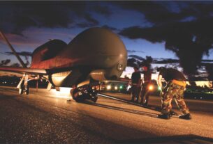
A case in point is the elimination of one most wanted terrorist named Baitullah Mehsud who had been hiding in the difficult terrain in South Waziristan in Pakistan’s tribal belt and directing terrorist operations both inside Afghanistan as well as inside Pakistan.
He had come to his father-in-law’s house to meet his second wife. While they were meeting on the roof of the house a cruising Predator drone aircraft detected him, identified him and shot two missiles that “took out” this thorn in American flesh.
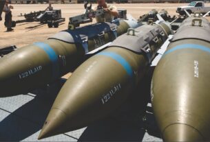
The accuracy of arrival on target of any moving object be it aircraft, missile, ship, submarine or spacecraft depends on a number of instruments that measure motion, speed, orientation and make corrections all through the flight path.
Among the early discoveries that enabled accurate navigation of military and commercial aircraft were the accelerometers combining three gyroscopes that dealt with the roll (rotation around axis), pitch (nose up and down movement) and yaw (nose left and right movement).
Situational awareness
This keeps the flying object largely steady in its orientation in keeping with its planned flight path. Wind and its direction of flow have a direct effect on the flight causing the flying object to drift away from its intended course.
It requires a constant update and midcourse corrections to ensure that the pilot has full and trustworthy situational awareness in the case of aircraft and spacecraft and requisite corrections ensure that the missile (either cruise or ballistic) flies through the desired path to reach its target.
The same applies to submarine navigation which too is affected by undersea currents that can cause even very large vessels to drift away from course. In both air and maritime navigation the deviations can be very large over the long distances that aircraft and ships/submarines have to traverse.
Usually navigation is understood as a factor to ensure safety but there are commercials aspects also involved.
The ability of a pilot to steer the aircraft over a path that will take advantage of tailwinds (breeze blowing from behind the aircraft) or avoiding headwinds (from the front) or flying over an area of turbulence makes for saving in fuel and directly affects the commercial viability of the airline especially in these days of constantly rising fuel prices.
In military terms, while the financial angle of flight planning remains germaine, operationally many other aspects are involved in aircraft (both fighter and transport) launch and recovery where flight is over rugged mountain ranges or vast expanses of ocean as the Indian environment presents itself.
It is not always easy to create high altitude airstrips to ensure swift deployment. Even when airfields are available the rarefied atmosphere tends to have an effect on the bomb-load in fighter aircraft and cargo-carrying capacity of freighter aircraft.
A flight path through mountain terrain (as well as over oceans) has to take into account the half-way mark between takeoff point to landing so as to ensure that the aircraft is able to return to base in case of bad weather enroute or push on keeping the laid down guidelines for reserve fuel and other parameters.
Alternate landing strips are pre-designated in keeping with safety requirements. It is just such wide spaces that dictate the inclusion of airborne refueller aircraft both for the sake of safety as well as to enhance the strike capability of existing aircraft types over longer distances.
Over such continental distances in which the Indian Air Force has to plan operations there is need for tried and tested flight paths that can be used when weather patterns change at short notice and standard operating procedures laid down for operations over the mountains as well as over the oceans.
The IAF lost without a trace a brand new An-32 transport aircraft while being ferried over the north Arabian Sea between the Arabian Peninsula and the Mumbai coastline. These kinds of operating conditions have a bearing on combat search and rescue during hostilities and on commercial air operations during peacetime.
Guidance system
Precision guidance and hence navigation is a closely guarded secret as India discovered from the time it conducted its first nuclear test in 1974 up to the time its conducted its second series of tests at Pokharan in the Rajasthan desert in 1998.
During this time India was subjected to the embargoes under the Nuclear Non-Proliferation Act which banned the sale of “dual-use” technology capable of being used both for military and civil purposes. Guidance systems were on the banned list.
That is why India put early efforts to acquire technology from abroad for the ring laser gyroscopes that would impart to its Integrated Guided Missile Development Program greater accuracy and improve what is known in missile jargon as “circular error probable” or CEP.
Making it indigenously was among one of the reasons why some of the missiles were delayed in their full development and deployment. Between 1974 and 1998 India also managed to master the technology for strap down inertial navigation systems (INS) which was an improvement on the accelerometers.
Modern aircraft use a combination of accelerometers, inertial navigation systems and ring laser gyros with positional updates from the Global Positioning System (GPS) and the Russian GLONASS satellite systems.
The earlier inertial navigation systems brought deviations from the flight path down to 1.7 nautical miles after one hour of travel time. Ring laser gyros bring about an accuracy rate close to 0.01 per cent per hour.
The developed nations have produced what is called Hemispherical Resonator Gyros carved out of quartz that have improved accuracy.
With the testing of the Agni III missile with a range of about 3000 km India used the indigenous ring laser gyroscope, making for a less than 30 meter CEP.
All future generations of Indian missile family be it the Agni, the Prithvi and the Akash will be more accurate with the inclusion of the ring laser gyros.
To be ready for possible navigation wars (Navwars) India is preparing to send aloft its own series of satellites for the Indian Regional Navigational Satellite System (IRNSS) consisting of seven satellites in geostationary orbit.
It is expected that the system will be in place by 2014. It is projected to be able to give an all-weather absolute position accuracy of better than 7.6 meters anywhere in India and within a radius of 1,500 km all along the Indian periphery.
It is to be seen whether this footprint will need to be extended given that India now has an operational Agni-5 with a range beyond 5000 km to ensure greater accuracy is moot.
An indicator of how important is the ring laser gyro to military applications is seen in its installation in the navattack system of the indigenous Tejas aircraft as well as in the Russian Sukhoi-30 MKI and later versions.
It is also an integral part of the 750-km range Shaurya submarine-launched missile being prepared for launch from the indigenous nuclear submarine INS Arihant and its sister vessels.
An indicator of how important is satellite navigation to the Indian scheme of thing is that even though it is participating as a full partner in the Russian designed GLONASS positioning system, New Delhi has simultaneously undertaken its indigenous IRNSS project.
The GLONASS will be a fallback in the event of disruption brought about by navwar which China has already indicated it is preparing for by shooting down one of its ageing satellites with an anti-satellite missile.