In recent years, outer space has become a strategically vital frontier for the defence forces keen on sustaining their strategic supremacy on the ground and stay at the winning edge of the war.
Indeed, orbiting satellites meant for a variety of end use serve as ‘ears’ and ‘eyes’ in the final frontiers for the armed forces on the lookout for a holistic picture of the strength and weakness of the rival forces.
It is not for nothing that high performance satellites, up in the orbital space, have been described as the ‘unseen guides,’ providing timely and relevant data on a dynamic basis to help the armed forces to take timely and right decisions in the fast changing battlefield scenario.
Along with cyber space, outer space has become a key platform for the defence forces to forge ahead with a winning warfare strategy. Unfortunately, India despite its tremendous strides in space exploration as highlighted by probes to Moon and Mars has not covered much ground in equipping its defence forces with space assets on requisite and large enough scale.
The need of the hour for the country is to set right this lacunae by launching a full-fledged space defence programme with a particular focus on meeting the needs of all the three wings of services for the satellite assets designed to perform a wide ranging tasks.
India’s political leadership should focus immediate attention on putting in place a institutional set up fully well capable of meeting the ‘space resources’ needs of the Indian defence forces, speedily and efficiently.
Against this backdrop, January 20 successful launch of IRNSS-1E navigation satellite, the fifth in the seven spacecraft IRNSS (Indian Regional Navigation Satellite System) constellation marks a major step towards boosting the country’s capability in the area of satellite based navigation which would be a major force multiplier for Indian defence forces.
The seven satellite IRNSS constellation, which is planned to be completed during the course of this year, with the launch of two more satellites, will free the country from its total dependence on the American GPS system.
In fact, India did encounter difficulties while accessing the restricted services of GPS. For only a home grown satellite system can give Indian defence forces a real ‘autonomy and freedom’ by allowing access as and when required.
There is no denying the point that for the Indian defence forces, an uninterrupted access to a home grown navigation satellite system, would be a big morale booster and game changer. For it was the non-availability of a satellite based navigation service that had hindered Indian army’s intelligence missions, before and during the 1999 short lived Kargil war with Pakistan.
However, with IRNSS in place, Indian defence forces will not have problem locating targets, navigating the movement of troops and supplies and launching precision weapons with a high degree of accuracy at enemy targets.
In fact, US was able to accomplish its military missions in Afghanistan and Iraq with a high degree of success mainly due to the availability of satellites navigation services.
An independent satellite navigation capability is also critical for the Indian defence establishments’ plan to refine and enhance the network centric warfare capabilities of the Indian defence forces.
Similarly, a large satellite navigation capability, is also crucial for the proposed tri service Indian aerospace command the formation of which is awaiting clearance from the Indian Government.
Credible method
For the defence forces, in the thick of operations in the remote and difficult to access war zones, a GPS system similar to IRNSS enables locating objects and landmass in the darkness and pave the way for co-ordinating the troop movements in a hitherto unfamiliar area in addition to facilitating reconnaissance as well as search and rescue operations.
The IRNSS spacecraft constellation is designed to provide accurate position information service to users in India as well as the region extending up to 1500-km from its boundary.
Further, the IRNSS constellation is equipped to provide a Standard Positioning Service (SPS) and Restricted Service (RS) and is expected to provide a position accuracy of better than 20-m in the primary service area.
Indeed, there is no denying the point that an independent satellite positioning system like IRNSS cannot but be a valuable, strategic asset for the country especially during the times of crisis when the possibility of international navigation satellite operators denying access for their service cannot be discounted.
Clearly, continuous and uninterrupted access to the exclusive, dedicated navigation satellite systems has now become indispensable for the combat aircraft, naval warships and ground based troops to acquire a head start in the battle zone and ultimately stay at the winning edge of the war.
For India, which is all poised to position itself as a technological and military super power in the none too distant a future, the need to own and operate an independent navigation satellite system has become the paramount need of the hour.
While India is now closer to meeting the satellite navigation needs of the defence forces to a large extent, the same cannot be said of the satellite resources for uses such as communications, surveillance, reconnaissance, electronic intelligence, weather forecasting and ocean watch.
Comprehensive plan
All the three services of the Indian defence establishment have projected their individual needs of the satellite resources in the years ahead with a view to sustain and refine their combat capabilities.
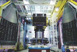
Incidentally, India’s first full fledged defence satellite, GSAT-7 meant for the exclusive use of the Indian Navy was launched in August 2013.
This satellite which has been fully integrated into the network centric operations of the Indian Navy is a multi-band space platform designed to provide secure and reliable communications over a wide oceanic swath and the Indian landmass. The satellite designed, developed and built by the Indian Space Research Organisation (ISRO) features UHF, S, Ku and C band transponders.
There is no denying the point that with a high performance communications satellite at its command, the Indian Navy would be in a position to enhance its situational awareness and intelligence gathering capability over the Indian Ocean region where China has stepped up its activities as a counterpoise to the Indian naval build up.
Further, with GSAT-7 in operational trim, Indian Navy will be able to overcome the limitations of the line of sight and ionospheric effects normally associated with the conventional communications devices.
With a view to boost its striking punch and expand its area of influence, Indian Navy has implemented a well conceived strategy to link up its long range missiles, radars and air defence systems on all the sea based assets to a central room through the highly reliable communications network provided by GSAT-7.
Indian Navy is also in a position to use the potentials of the Oceansat-2 satellite launched in 2009 by ISRO to monitor the events including the naval movements in the oceanic stretches.
A follow on GSAT-7A satellite meant for the exclusive use of the Indian Air Force (IAF) is planned to be launched before the end of this decade. This will be similar in capacity and configuration to GSAT-7.
A third satellite in the series meant for the use of the Indian Army is also in the offing though its launch schedule is still to be finalized.
Interestingly, the futuristic communications satellites designed for the use of Indian defence forces will make an enhanced use of Ka band frequency to ensure security and provide a greater bandwidth.
Use of higher frequency bands including Ka and X makes for an enhanced security of a satellite communications system.
Significantly, the GSAT-6 advanced communications satellite launched by means of the home grown, Mark Two version of the three stage Geosynchronous Satellite Launch Vehicle (GSLV) in August last is being accessed by the Indian Army units located in the distant, difficult to access areas for the rapid, efficient, two way communications.
In areas where it is difficult to set up a conventional communications link, potentials of GSAT-6 come in handy for a smooth, two way communications.
This digital multimedia broadcasting spacecraft featuring a large unfurlable S-band antenna is ideal for the Indian Army units keen on getting information of strategic importance in a reliable, secure manner and on a real time basis. The satellite carries a national beam in C-band for authorised strategic users.
This high powered satellite has a built in capacity to communicate with the small, hand held terminals. The capability of GSAT-6 for two way transmission of voice, video and data in a secure mode fits in well with the strategic communications philosophy of the Indian defence forces.
Communication grid
This feature would be particularly beneficial for the armed forces keen on getting a holistic battlefield view. The potentials of GSAT-6 can also be harnessed for boosting the rapid strike capability of defence forces through the timely acquisition of the relevant information.
For the defence forces operating in remote and difficult to reach areas, the GSAT-6 capability can be harnessed for establishing a hassle free communications link. What is more, the GSAT-6 capability can also be exploited for strengthening the network centric warfare strategy.
India’s defence set up has now fully well realized that a satellite based network centric approach helps derive advantages in terms of the ability to stay ahead of an opponent and dictate the dynamics of engagement.
By all means, the satellites hold the key for a well coordinated and synchronized operations of a battlefield strategy by seamlessly integrating weapons systems, missiles, radars and sensor suits, UAVs, UCAVs, electronics and communication network, fighter jets, transport aircraft, logistics and support systems and defence forces spread across a vast geographical swathe for sustaining ‘strategic superiority’ from the word go.
Denying the adversaries access to space through the degradation or destruction of his satellite resources has now assumed more than usual importance in the modern day warfare.
Now India will plan a new security satellite. According to the plan unveiled by DRDO, while the payload of the satellite would be designed and developed by the Hyderabad based Defence Electronics Research Laboratory (DLRL), the satellite bus and launch support would be provided by ISRO.
This Rs 1,000-million satellite equipped with sensors to pick up conversation and detect espionage activities will be launched by means of the four stage, reliable Indian space workhorse PSLV (Polar Satellite Launch Vehicle).
Sources in DRDO point out that the electronic intelligence system on-board this satellite would help keep an eye on hostile satellite in addition to intercepting and jamming satphone communications.
Right at the moment, Indian defence forces have to make do with limited access to the satellites-most of which are dual use systems-being operated by ISRO to meet their strategic and tactical needs.
The plan is that access to the space platforms on an uninterrupted basis can alone help the forces to obtain battlefield transparency of rival forces.
However the biggest concern is that whether ISRO with its limited infrastructure for building and launching satellites would be in a position to fully well cater to the rapidly expanding space resources needs of the defence forces.
The Technology Perspective and Capability Road Map (TPCR) unveiled by the Indian Defence Ministry envisages an ambitious plan for a satellite based communications network with high data rates and multi band operations for voice, data and allied applications.
In addition to exploiting the satellite capability for communications and enhancing the situational awareness at all levels of operations Indian defence forces could make use of advances in communications and sensor technologies to give a greater punch and thrust to its warfare strategy.
However, keeping the information and communication network in operational trim in the context of the expanding scope of cyber war has assumed more than the usual significance. In particular, precaution must be exercised to ward off the threat of jamming to which satellite communications systems are vulnerable.
Indian defence forces can have limited access to the data transmitted by the high performance, high resolution earth observation satellites in IRS (Indian Remote Sensing Satellite) constellation being operated by Indian Space Research Organisation (ISRO) to enhance its intelligence and surveillance capabilities.
Incidentally, earth observation satellites meant for civilian uses can easily be harnessed for surveillance and reconnaissance by the defence forces. For remote sensing and surveillance are considered two faces of the same coin.
India’s microwave, radar imaging satellite, RISAT -1 satellite can be a valuable asset for the Indian defence forces located in mountainous stretches that remain clouded for most part of the year.
There is no denying the point that data from an active, microwave imaging satellite capable of operating on round the clock basis, even under extremes of atmospheric and environmental conditions, could help Indian defence forces to get a realistic picture of the scenario in a dynamic mode.
Of course, ISRO describes RISAT-1 as a civilian space platform meant to enhance India’s earth observation capability with special reference to floods, land slides, cyclones and disaster management.
Similarly, the Cartosat series of satellites designed for cartographic applications could help Indian defence forces get vital features of the enemy territory studded with strategic installations.
Futuristic technology
The futuristic Cartosat-3 satellite of ISRO will be a hyper spectral imaging spacecraft capable of providing high resolution, multi scene images of the areas of interest.
With as many as ten remote sensing spacecraft in service, ISRO operates one of the largest constellations of earth observation satellites in the world.
These satellites carry a range of instruments that offer data in wide ranging spatial, spectral and temporal resolutions to cater to varied requirements.
The data from these satellites find application in areas including resources management, environmental monitoring, disaster warning, weather prediction and urban planning as well as infrastructure development.
Remote sensing satellite can watch with great details “events and activities” on the ground that could ultimately help get a picture of military movement of rival forces.
IAF’s defence space vision 2020 outlines the need to evolve a strategy for the optimum utilization of space assets for sharpening its combat edge.
By all means, for IAF the uninterrupted access to dedicated constellation of military satellites is critically important for sustaining its deep and long strike capability. In fact, DRDO has hinted at a well conceived plan to build and launch a series of defence satellites with surveillance, imaging and navigation capabilities.
In particular, Indian Army is keen to use satellites to monitor the presence of missile silos, location of targets, troop deployment and movement along the borders which will facilitate combat operations.
For the Indian defence forces, satellites are crucial for improving the operational trimness of C4ISR (Command, Control, Communications, Computers, Intelligence and Surveillance) system.
Timely and efficient use of satellite systems should hold the key to the success of a network centric warfare.
Way back in March 2007, during President’s fleet review of IAF, Dr A P J Abdul Kalam had observed, “I visualize IAF of 2025 to be based on our scientific and technological competence in the development communications satellites, high precision resources mapping satellites, missile systems, unmanned supersonic aerial vehicles and electronics and communications systems”.
Indeed, meteorological satellites predicting weather to facilitate bombing missions, navigation satellites guiding lethal weapons to the designated targets, reconnaissance satellites locating the exact geographical position of the defence installations, electronic ferret satellites gathering data on radio frequencies and communications satellites providing real time, secure data links between defence forces scattered over a vast geographical stretches have all become puppets on the strings of modern day warfare.
At the end of the day the, the varied and versatile uses for which satellite assets can be harnessed, is left to the vision and imagination of the defence forces in the thick of the battlefield.