
After what the Chinese have just done to us in the Ladakh sector of Jammu and Kashmir, talk of an “Aerospace Command” raises visions of castles in the air while terrestrial bastions on earth are being assaulted and violated.
While there will, eventually, be a need to set up such a command headquarters to administer the space-based defences, the more urgent requirement is of measures to prevent the Chinese bullying us on the ground east of our Daulat Beg Oldi outpost in Ladakh and dictating terms that will indeed make India look like the proverbial Chinese Paper Tiger.
The questions that come to mind are: What were space-based assets doing when the Chinese were creeping in on us (of course it has to be taken for granted that our troops on the ground were sleeping as they were when Kargil happened)?
Could there not have been some way to look, at least at such vulnerable sections of the Line of Actual Control-of course it could be argued that if you cannot see it on a map in your hand what do you expect to see from 30,000 miles in space (apart from the Great Wall of China)-and be able to sound an early warning?
How do you expect to prevent a Pakistani perfidy if, heaven forbid, the Indian leadership is so dumb as to agree to withdrawing from Siachen if the Pakistanis accept the delineation of the Actual Ground Position Line (the current Chief of Army Staff is on record that if the Pakistanis agree to sign the AGPL then Indian troops can be withdrawn)?
Do we have the means of long-range surveillance and instantaneous military responses or will we, as in Kargil, have to wait till a Kashmiri shepherd brings us valuable ‘actionable intelligence’ about what the Pakistanis are doing before we fall back on the grit and guts of the Indian soldier to retrieve what our stupidity lost for us?
Space assets
We need space-based assets to help us know what the Chinese are doing behind their lines in the Tibet Autonomous Region, the Chengdu Military Region to the east and the Xianjiang Military Region to the west of the point where the current infiltration has taken place.
It is obvious that both in the timing and the placement of the intrusion a great deal of military thought and diplomatic finesse has been deployed. India needs to know what the kind of threat it faces from China before it makes its move.
It has avoided making a knee-jerk reaction of the 1962 “throw the Chinese out” kind but it can also not afford to be seen not doing anything on the ground even as the Chinese are almost daily adding more tents to widen the area of ingress. That it has come for a long stay is obvious (not by counting the number of tents but by the fact that from now to November it can keep India squirming between chopsticks even as it prepares a broth to cook our goose in).
We need to be better able to read and analyze every Chinese move to be able to respond with some sense of dignity and purpose. One thing is clear that it chose the point south-east of the Indian post at Daulat Beg Oldi to create a two-pronged axis of penetration- one towards Leh to cut off the Siachen Glacier and the other towards the Uttarakhand-Himachal border to prevent India from easing pressure on Siachen.
If India does not buckle under the Chinese diktat and stop, as asked, its infrastructure projects along the Line of Actual Control, then China will need to do something about it. How it will do it will have to be ascertained through space-based assets already extant or what, as the DRDO promised not long ago, can be launched at short notice.
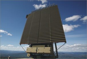
Currently, we are using unmanned aerial vehicles (UAVs) to monitor Chinese activities but these are constrained by range and service ceiling and are vulnerable to be shot down by Chinese helicopter gunships.
At this stage what India needs is a panoramic overview of a wide swath of Chinese territory from Chengdu to Xiangjiang and this can best be done by a high-flying satellite to be able to tell about troops concentrations and which side they could be heading. The Daulat Beg Oldi maneuver could be a cover for a strike into Arunachal Pradesh or the intention could be to make a deep strike through Himachal Pradesh that could make the defence of Siachen untenable.
Dedicated space cell
In this context the Integrated Space Cell was established within the Integrated Defense Services headquarters of the Indian Ministry of Defence, which can be described a kind of half-way house between the facilities available with ISRO and the proposed tri-Service Aerospace Command. It was created soon after China demonstrated its ability to shoot down a satellite in space using a medium range rocket.
Unlike an aerospace command, where the air force controls most of its activities, the Integrated Space Cell will coordinate operations between the three Services as well as civilian agencies like ISRO, launch vehicle centre, satellite production units and foreign collaborators involved in producing space products. The armed forces are increasingly depending on satellites for communication, aircraft and missile guidance, reconnaissance and surveillance. Satellites are also essential for civilian purposes such as weather forecasting, disaster management and communications.
This has made it important to work out measures to protect India’s space-based assets and make the civilian and military applications complementary and supplementary.
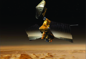
In its stable of satellites the Integrated Space Cell has nine operational IRS class satellites; the one-meter resolution Technology Experiment Satellites; the RISAT-2, or Radar Imaging Satellite 2 built in collaboration with Israel has a synthetic aperture radar. It has a day-night, all-weather monitoring capability and has a resolution of one metre. Potential applications include tracking hostile ships at sea.
Though the Indian Space Research Organisation has scrupulously insisted that it is meant for civilian applications like earth observation, especially during floods, cyclones, landslides and in disaster management, in a more effective way analysts have highlighted its military potential and have unabashedly called it a spy satellite-a dual role with which India should be comfortable.
It needs to be recalled it was just this kind of dual role capability that made ISRO fall foul of US technology control regimes. It is a measure of Indian capabilities that it can no longer be turned away from the intent and purpose of its creation by farsighted Indians.
Among satellites that can unabashedly be cited as having military capabilities are the Cartosat-2 and 2A and 2B series that have the capability of being maneuvered 45 degrees along the direction of its movement which is a polar sun-synchronous orbit which could take in large parts of China along their routes.
This ability to maneuver a satellite gives hope that the Chinese capability to shoot down space-based assets of other nations can be rendered innocuous by the maneuver potential incorporated in Indian satellites. It is relatively easier to hit a stationary object in space than one that can sidestep an incoming rocket. Cartosat-2B has an improved resolution of 80 cm (instead of the one meter of the others) which makes it more useful in military tracking and surveillance.
Thus in the Integrated Space Cell the Ministry of Defence has a viable facility in place that can deliver what is required in the immediate context of the latest Chinese incursion and the long-term fallout that that could engender.